


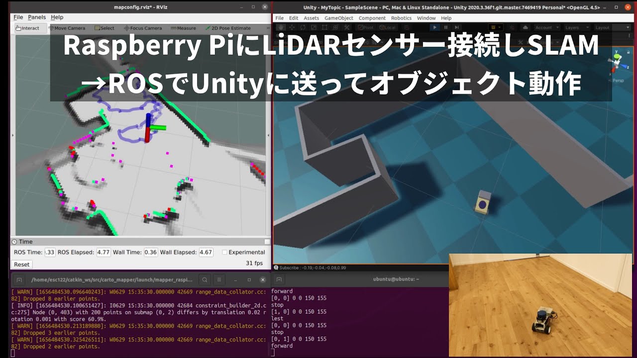
Autonomous Raspberry Pi robots navigate their environment without bumping into things. Using an ultrasonic sensor, such as the HC-SR04, to detect obstacles is a fairly common tool for Pi-based robots and cars but this robot car project, created by maker and developer エス ラボ (S Lab), is going even further by mapping out a room with the help of a LiDAR sensor.
The car has a Raspberry Pi 4 4GB at its core and as it drives around, LiDAR sensor data is transmitted from the Pi to a nearby PC which uses a SLAM-based (simultaneous localization and mapping) system to create a virtual, 3D replica of the room surrounding the Raspberry Pi. The program also provides a virtual representation of the car in Unity to estimate its position in the room.
This is one of many projects created by S Lab who specializes in various microelectronics projects. They’ve created several Pi-based systems that synchronize with Unity to create complimentary virtual assets. According to S Lab, they also have experience with JetsonNano boards, M5Stack modules and programming in Python. You can find a history of projects on their official blog.
This project was built using a Raspberry Pi 4 4GB model and uses a YDLIDAR X2L LiDAR sensor to detect the 3D space around it. The Linux-based PC used for processing the data is in the same room and running Ubuntu 20.04.4. If you wanted to make something similar, a Raspberry Pi 3B+ may work but you’ll benefit from the processing power of the Raspberry Pi 4 especially with 4GB of RAM.
S Lab was kind enough to make the project open source and has shared the code for interested parties over at GitHub. S Lab explains, the rotation angle and position data is transmitted to unity using ROS (robotics operating system) along with ROS-TCP-Connector 0.7.0 which is also available at GitHub.
If you want to recreate this Raspberry Pi project, you should check out the official demo video shared by S Lab over at YouTube. Be sure to follow S Lab for more impressive projects and fun creations using the Raspberry Pi.
