TV-signal based BPS tested as fallback for GPS — digital TV infrastructure could come to the rescue if satellites are compromised
Broadcast Positioning System (BPS) replaces satellites with ATSC 3.0 digital TV signal data.

Progress in developing the Broadcast Positioning System (BPS) was recently charted at the NAB (National Association of Broadcasters) show. CNX Software reports that BPS is being positioned as a backup, alternative, or confirmation data source for the Global Positioning System (GPS). However, BPS has its particular strengths and weaknesses.
GPS can be as vital to some portable smart device users as mobile and Wi-Fi network data. However, this satellite-based system, which provides precise location, velocity, and time information, is not always available and can be interfered with by bad actors. Recent reports of GPS interference over the Baltic Sea, the Black Sea, and the eastern Mediterranean make for worrying reading. On the other side of the conflict, Ukraine is known to have used GPS spoofing to repel Russian drone attacks.
GPS is under attack, and its reliability is easily put into question, so a backup positioning technology seems like a great idea. Being able to reuse existing infrastructure would be a bonus, and what is more widespread and suitable than TV broadcast antennae?
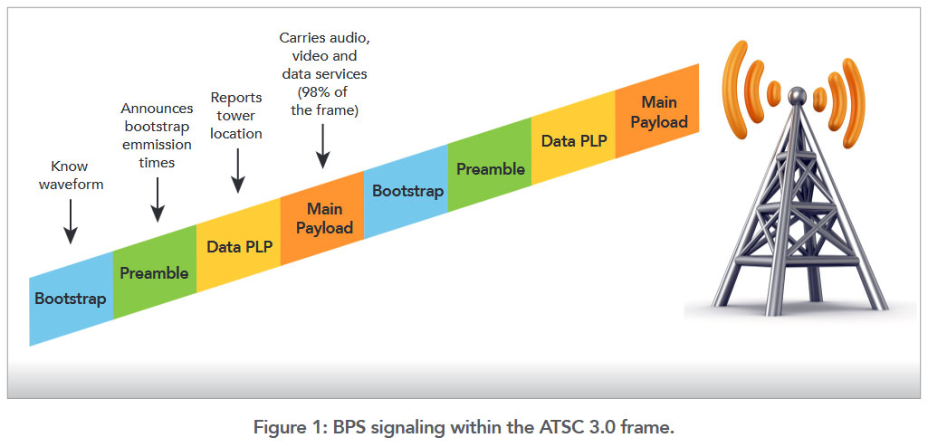
BPS uses TV signals for timing and positioning data, but the base stations must be broadcasting ATSC 3.0 'Next Gen TV' signals, specifically for this technology. The BPS tech works by adding an ATSC frame to the output, and this will usually provide timing accuracy to 100ns, which is good but not quite as good as GPS (~10ns). However, for BPS positioning, you will need to be in the signal range of four transmitters, and even then, accuracy will be in the order of a 100-meter radius...
According to the source report, BPS is currently being tested and is approaching the fourth (of six) development phases. At the latest, by 2027, we should see ATSC 3.0-based timing become available to the public. Then, by 2029, ATSC 3.0-based timing should be added to the mix. Of course, some kind of BPS receiver will be needed to use this positioning system, whether public or not.
While the BPS technology doesn't impress in its stats, compared to the dominant GPS (for example), it is hard to argue against its use for verifying GPS data. Also, it is always good to be able to reuse existing infrastructure to add value. Hopefully, the U.S. won't need this GPS backup in its home turf, where ATSC 3.0 digital TV signals are found. Currently, coverage is fair, with around 75% of U.S. households capable of receiving ATSC 3.0 signals, which can deliver 4K HDR visuals. We assume that percentage will improve over time.
Different digital TV standards exist in other regions, such as the popular DVB-T/T2. However, we don't know if positioning data can be added to those broadcast signals. The Russians might be interested in melding DVB-T with their Glonass satellite positioning system for backup/verification. Likewise, Europeans may find implementing some non-satellite backup/verification for their Galileo satellites worthwhile.
Get Tom's Hardware's best news and in-depth reviews, straight to your inbox.

Mark Tyson is a news editor at Tom's Hardware. He enjoys covering the full breadth of PC tech; from business and semiconductor design to products approaching the edge of reason.
-
COLGeek Radio resection. Old manual map folks should recognize the concept in play. The more sources used, the more accurate the location. Pretty interesting re-use of current tech.Reply -
bit_user Reply
Well, if satellites are taken out by either hostile action or perhaps an unusually strong geomagnetic storm, then the scope of the impact could be much larger than the localized jamming incidents referred to by the article.The article said:Hopefully, the U.S. won't need this GPS backup in its home turf, where ATSC 3.0 digital TV signals are found.
As for accuracy, there are a couple reasons why approximate accuracy might be good enough. First, it could reassure you that your GPS signal isn't being spoofed. Second, having an approximate location could be enough for a navigation system to lock onto landmarks for fine navigation. GPS-based nav systems already seem to use this trick, affixing your location to the nearest road and using cues from turns. Systems with cameras (e.g. self-driving cars or a smartphone app) could also match visual key points extracted from a dataset like Google's Street View, although that wouldn't work too well when you're not around buildings or other distinct landmarks.
Lastly, recent research has provided new insight into how some migratory birds use the Earth's magnetic field to determine their location. When another positioning system isn't available and weather conditions or foliage prevents using the sun or stars, that seems like a pretty good fallback.
https://phys.org/news/2024-11-magnetic-displacement-held-theories-migratory.html -
helper800 Reply
Takes me back to the scouts when navigating a mountain with a compass and a topological map. With a topological map in hand I feel relatively confident of my location, lest I am in a plains area with no distinct landmarks, or a dense thicket that disallows for the seeing of landmarks.bit_user said:Lastly, recent research has provided new insight into how some migratory birds use the Earth's magnetic field to determine their location. When another positioning system isn't available and weather conditions or foliage prevents using the sun or stars, that seems like a pretty good fallback.
https://phys.org/news/2024-11-magnetic-displacement-held-theories-migratory.html -
bit_user Reply
A magnetic compass only gives you the declination, though. If you had not even a remote idea where you were, then just that piece of information wouldn't enable you to pick the right map to look at and try to match against landscape features.helper800 said:Takes me back to the scouts when navigating a mountain with a compass and a topological map.
In the article I linked, the researchers found that the birds they studied are also using magnetic inclination, which enables them to estimate their location with no other information. They were even shown conflicting clues, like stars and magnetic intensity, which had no effect on their choice of which direction to fly. -
helper800 Reply
While true, unless I was drugged and placed on a random location on earth, without enough context clues, I would not be able to figure out where I was. It would all depend on whether or not I had maps to determine exactly where I was, and of course, a compass. I regularly play geoguesser as well, but this is a bit beyond the conversation. Birds would know much quicker with no context clues needed.bit_user said:A magnetic compass only gives you the declination, though. If you had not even a remote idea where you were, then just that piece of information wouldn't enable you to pick the right map to look at and try to match against landscape features.
In the article I linked, the researchers found that the birds they studied are also using magnetic inclination, which enables them to estimate their location with no other information. They were even shown conflicting clues, like stars and magnetic intensity, which had no effect on their choice of which direction to fly. -
kanewolf Reply
The key thing that most people don't understand is that GPS is really just very accurate clocks. If there were atomic clocks at the TV transmitters to provide the equivalent time accurate signals, then the TV broadcast positioning could be as accurate as GPS. The GPS receiver does all the hard work. The satellites just say "Here is where I am, and here is what time it is".... Since TV transmitters don't move (unlike GPS satellites), then "Here is where I am" is pretty simple. All you need is the super accurate time that GPS satellites have.COLGeek said:Radio resection. Old manual map folks should recognize the concept in play. The more sources used, the more accurate the location. Pretty interesting re-use of current tech. -
bit_user Reply
Sure, but that experience doesn't translate to every context where nav is used. Therefore, we need tech based on more than just declination + mapping.helper800 said:While true, unless I was drugged and placed on a random location on earth, without enough context clues, I would not be able to figure out where I was.
It'd be slick if BPS could directly complement GPS by telling you the coordinates of each tower, in addition to its GPS-compatible time. Then, by receiving any mix of 3 sources, you'd be able to triangulate your position.kanewolf said:Since TV transmitters don't move (unlike GPS satellites), then "Here is where I am" is pretty simple. All you need is the super accurate time that GPS satellites have.
In fact, if you could estimate your distance from just two BPS broadcast towers and then move around enough for an inertial nav + compass to generate more data points, that'd be enough to fix a precise location. Every phone has accelerometers and a magnetic compass. They can also use AR tech (i.e. SLAM) to do much more precise mapping.
Thinking about this a bit more, if you used SLAM + compass over a large enough baseline, then you ought to be able to compute your location using a single GPS satellite or BPS tower. Basically, triangulation can work both ways. You can sit in a single spot and triangulate against 3 references, or you can accumulate at least 3 data points by moving around, so long as you know the relative locations of those points and the distance of each to a single, common reference.

